Wednesday, August 3, 2016

J - Jug End Loop Trail, Egremont, MA

Wednesday, August 3, 2016

J - Jug End Loop Trail, Jug End State Reservation and Wildlife Management Area, Egremont, MA

  This hike took me the farthest from home (so far), but was recommended as a gem by BerkshireHiking.com. It did not disappoint!

It was a bit tricky to find (there was no signage pointing to the parking area), but thankfully there was some guidance from the hiking website trail account.

Choosing to hike this on a Wednesday morning, unfortunately it wound up being the day that the mowing crew was managing the trails. I understood that this would likely be the least-busy day for hikers. Fortunately, it didn't take long to get deep enough into the woods, to get away from the mower/weed-eater noise!

 If you wanted to make this a shorter loop hike, you could be perfectly content just meandering around the maze of mowed trails in the meadow! While that was a nice start for me, it was great to get into the woods!

Leaving the meadow, into the woods!

 The trail was an old forest road; it was wide, but stony! The trail followed a mountain stream, so once the lawnmower noise died off, the sound of flowing water created a nice ambience!

 
Overlooking a nice stream

The trail pitched upward, and finally I heard some birds calling! I was looking for a "furnace" at which point, the trail would loop back around. I found a fireplace and chimney, and signage for an additional loop. I decided to play it safe, and take the "main loop." It was the right call!
 The return leg of the loop had a different feel. It started in the woods, but then the trail emerged along meadows in bloom with wild bergemot and goldenrod flowers.
I've never been to the Alps, but this was nice too!
When I stopped to eat some fresh blackberries just before taking the below photo, I saw and heard something stir and make a "huffing" noise in the brush. A bear? I didn't investigate further!
That sounded like a bear...

 Overall, the meadow in bloom in the valley was a unique environment to me, so I rather enjoyed this hike! Although it was an hour drive up, and an hour drive back, for a bit over an hour's hiking, I felt it was worth it, (though it might not be for everyone).
 Notable Sightings:
  • Black Bear? (Heard?)
  • Goldenrod
  • Wild Bergemot
  • Brown-eyed Susans
  • Red-eyed Vireo (heard)
  • Black-capped Chickadee (heard)
  • Common Yellowthroat (heard)
  • (Great Spangled?) Fritillary

I - Iron Mountain Preserve, South Kent, CT

Monday, July 25, 2016

I - Iron Mountain Preserve, South Kent, CT

 After a drive down Richards Road (I've been past it so many times on my commute, but never been down it!), and a few U-turns, I found Iron Mountain Preserve!

An unnecessary bridge in the middle of a drought!
 The hike started downhill, over several would-be creek crossings, but not in this drought! I lost the trail for a bit by an uprooted tree, but then found it again. That would be the theme of this hike:  a trail that is little-used, and even less-frequently maintained!

The aforementioned uprooted tree!
 The trail turned over-grown and a bit muddy. I startled a white-tailed deer in for a drink. 
 After crossing the first of several rock walls, I finally started the "lollipop" loop!
The start and end of the lollipop loop!
 The trail was easy-going enough, but started to climb to a height rather quickly. While there was not really a vista from the "summit" of Iron Mountain, it felt like an achievement to reach the top!
 
Not exactly the most well-maintained trail!

 
An unexpected glacial erratic!
All-in-all, this was a pleasant hike, but not too much that was particularly outstanding. There were no really unique habitats or wildlife sightings, no unique historical artifacts or structures, and no scenic vistas. According to the Kent Conservation Commission's "Kent Trails" guidebook, Iron Mountain was a source of mined ore, and the forests were used as charcoal for nearby ironworks. There were supposed to be obvious remnants of early charcoal pits, but as I didn't know what to look for, I didn't see any.

I'm glad it's protected land, but perhaps some interpretive signage could help hikers understand its historical significance. But any day in nature is a day well-spent!

Notable Sightings:
*Note: without cell-phone reception, I couldn't keep track of bird sightings with eBird
  •  White-tailed Deer
  • Glacial Erratic (boulder deposited by glacial retreat)
  • Reishi Mushroom
  • Bolete (mushroom)
 

Tuesday, July 19, 2016

H - Haystack Mountain State Park, Norfolk, CT

Tuesday, July 19, 2016

H - Haystack Mountain State Park, Norfolk, CT

     
Lookout Tower at the top!   
Back in the swing of things! After a 3-day conference in Boston, and a visit from some Kentucky friends, I had a free day to hit the trails! I was undecided between Hidden Valley Preserve in Washington, or Haystack Mountain, which I had already ascended!


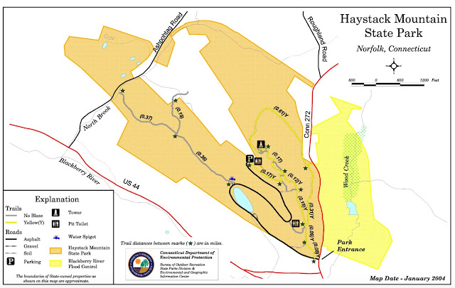
I decided on Haystack, but I would take "the long way," about a 2-mile loop around the back side of the mountain (see map above: Yellow trail).
"Steps" on the trail

Most people drive up the road almost to the top, then hop on one last steep stretch of trail to the summit. A stone and concrete lookout tower, constructed in 1929, allows for stunning panoramic views of the Taconic Range of New York, and the Berkshires of Massachusetts, as well as the Litchfield Hills of Connecticut.

An open meadow before entering the woods

 The "Yellow" trail starts off the park road as soon as you turn in off Route 272. There's not really a parking area here, but there's enough of a flat shoulder to pull off and park. The first leg of trail from the road up until an open meadow with mowed trails, is a bit overgrown (with some poison ivy). I could tell most people didn't follow this spur.


After it reached the mowed meadow, the trail entered the woods. The trail was wide and smooth, with few rocks or roots, and clearly blazed with yellow. The ascent was steady, but not steep. I was looking to take the right "fork" and follow the loop counter-clockwise to the summit.  I guess I missed the "fork" (more on that later), because I was soon ascending a steep, rocky path, that seemed familiar. This was the path that most people travel up to the summit. Rather than backtrack, I would just run the loop in reverse once I reached the summit.
Haystack Mountain Summit Tower
Just one of the amazing vistas! (Sorry for getting in the way!)
I took one "lap" around the overgrown road just below the tower, and was about to head down the mountain, when I heard a rustle in the canopy. I looked up, expecting a brance or acorn to fall from the trees, but instead it was a gray squirrel in a nose dive! It must have fallen 20 feet, but then sprung back up the neighboring tree, so I guess it was okay. I had never seen that in all my life! 
 m
One of the panoramic views from the tower

The spooky, curved staircase down the tower!
So I headed off down the other half of the yellow loop trail. It was mainly an old mountain road, but a soft enough, unpaved surface. It was quite a slope, so the pace was quick. I paused for a moment to have a whistling conversation with a black-throated green warbler, but I couldn't coax it out of its hemlock hiding spot. I passed a hiker hustling up the way I was heading down.

The downhill trail
After passing through some old rock walls, the trail rejoined the main trail at a less-than-obvious junction. No wonder I had missed the turn on the way up!
"Busting through" an old rock wall!
I helped a couple of hikers with directions when I got back to my car. I also saw the ascending hiker jogging down the road. I asked him if he had stopped at the top, but he said he just went "right up and back down!" Amazing!

As I was having a banana snack in my car before leaving, the White Memorial Summer Camp van passed by, then reversed until it was even with me. A familiar face (my wife) asked if I wanted to join them on an ascent to the summit. I declined, but wished them well! 

I contemplated tacking on a hike at Hidden Valley Preserve (a bonus "H" hike), but my feet had a dissenting opinion. So home for lunch!


Notable Sightings:
  • Red-eyed Vireo
  • Eastern Wood-Pewee
  • Black-capped Chickadee
  • Hermit Thrush (seen at summit)
  • Black Vulture (seen soaring at eye level from tower)
  • Gray Squirrel (falling out of tree!)
  • Black-throated Green Warbler (had a whistling conversation with)
  • Black-and-White Warbler (saw!)
  • Common Yellowthroat
  •  Blue-headed Vireo? (heard)
 

Friday, July 8, 2016

G - Green Circle Trail, Steep Rock Preserve, Washington, CT

Friday, July 8th, 2016

G - Green Circle Trail, Steep Rock Preserve, Washington, CT

I'll admit this one was a bit of a stretch to fit the alphabet criterion! I was also contemplating the Jessie Gerard Trail in Peoples State Forest, but we had already hiked that one last year.

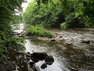
Old Railroad Bed along the Shepaug River


 The first section of this 3-mile trail was an old railroad bed; so it was level, straight, and wide. To be honest, though it followed the Shepaug River, and had a nice, fern-covered slope to its right; I was eager to get into the part of the trail that wasn't being used by casual walkers and joggers. So I kept my pace quick.


The Mighty Shepaug!
I noticed that on the other side of the river, there was a lot more traffic: cars, families, and kayaks. A friend had told me that in season, one could drive a car almost all the way to a suspension bridge and railroad tunnel along this road. I opted for hiking this distance instead. When I go back with the family, we'll cut to the chase. But I feel it's more of an enjoyable experience if the destination is earned over land on foot.

They weren't kiddin'!

The trail quickly turned into a narrow, rooty, rocky, undulating path along the river. I could see why this was not fit for horse traffic, nor preferred by casual walkers or joggers. This was the type of trail I was hoping for! It was a bit slick due to rain overnight, so I had to pick my way methodically.

Well-Constructed and Bouncy!


My plan all along was to divert from the Green Circle Trail over the famous suspension bridge, then on the Blue Square Trail to the railroad tunnel. Unfortunately without a printed map, I tried to rely on the map from the website on my phone. Of course the reception was limited, so I had to work from my less-than-photographic memory!


This doesn't do it justice with nothing for scale!

With a bit of improvised scrambling along a series of well-worn, unofficial herd paths, I made my way down to the railroad tunnel. It was massive, and a bit spooky! When I walked in, I couldn't see any light from the other end, so I wondered if it had been blocked off. 

Proceeding slowly, I finally saw some light peeking in up ahead.

After some video and echo tests, I headed back up to the trail.
Still not enough scale to capture the immensity!


Finally, I got a strong enough signal to have access to a usable map, and just in time. There was a series of tricky connections to get back to the bridge, and after an unplanned detour, I made it back to the Green Circle Trail!

Baby Fern Rock
 Overall, this was a fine hike! It challenged me with tricky terrain, enough uphills for a workout, and some cool features (bridge and tunnel!) I would recommend this one for an experienced hiker, confident in their footing and stamina. Also, there are plenty of points to access the river for fishing, and some nice picnic spots (with tables). If this hike seems a bit too much, there are several other trails that are shorter and flatter, or there's always the drive-able road all the way out to the bridge and tunnel.

Large Reishi Mushrooms!
Made it in just under 2 hours!

Notable Sightings:
  • Great Blue Heron (scared up from river)
  • Black-and-White Warblers (saw 3!)
  • Winter Wrens (recorded their song)
  • Red-breasted Nuthatch
  • White-breasted Nuthatch
  • Black-throated Green Warblers
  • Mallard (male on river)
  • Reishi Mushrooms
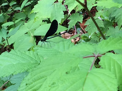
  • Ebony Jewelwing Damselflies
    Ebony Jewelwing Damselfly

F - Falls Brook Trail, Barkhamstead, CT

Thursday, July 7th, 2016

F - Falls Brook Trail, Barkhamstead, CT

After a seemingly long layoff from hiking, due to a surprisingly excellent family reunion in Buffalo, I was finally back at it this morning.

While this was originally planned to be a family hike on a weekend, after having hiked the trail, I'm glad that it wasn't. It proved to be tricky footing at times, and was certainly a good workout going uphill almost the entire hike back in.

The drive up was lengthy, but I got a feeling as the landscape became more wild that this was "bear country," and that I might have to do a little singing or whistling to keep all the bears away [I didn't see any!]

The hike was pleasant. It was mostly downhill on the way out, meaning it would be a long uphill on the way back! It had been dry for about a month, so all of the "streams" on the way down had dried up. Considering that, I didn't have high expectations for the waterfall.

Red Eft!
 There were very good (sometimes excessive) blue-blazes and signage, some hand-scribed.

 Even though it was low-water, the falls were very nice. As the "Connecticut Walk Book" mentioned, there was a "natural Air Conditioning" at the base of the falls. Any waterfall enjoyed in solitude is okay in my book! A perfect spot for reflection, with a nice, clear, deep pool at the base.


Cool rock revealed by weathering water!


 The trail continued in a nice loop. Had there been more rain leading up to this point, the "confluence" of West and East forks of Falls Brook would have been more impressive!
Very Mossy Confluence!

 From the crossing of the East Fork, it was steady uphill as I expected, but I pushed without stopping all the way to the trailhead. By the end, my heart was pumping, and I had a good amount of perspiration going!

Some impressive wild grapevines!

Success!
I looked at the time, and it literally had been just under an hour! I was considering going for another hike, but I had some important errands and a time table over my head. Nice little jaunt! 

Notable Sightings:
  • Red-Eyed Vireo (heard)
  • Hermit Thrush (heard)
  • Black-throated Green Warbler (heard)
  • Winter Wren (heard)
  • Red-breasted? Nuthatch (heard)
  • Red-spotted Newt (Red Eft)
  • Green Frog
  • Blue Jay (heard)
  • Veery (heard)
  • Wood Thrush (heard)
  • Ovenbird (heard)
  • Yellow-bellied Sapsuckers (saw)