A - Mt. Algo, Appalachian Trail
Kent, CT
As I had mentioned in my previous blog post, I had made a vow to "conquer" Mt. Algo on the day following our last day of school. I teach 5th/6th grade science at Kent Center School, a public, K-8 school in Kent, Connecticut.
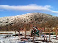
Every day as I walk from my car into the building, I am greeted by Mt. Algo. It not-quite-towers over the Housatonic River valley, The Kent (private) School across the river, and our school. Below are some of its many faces.
 |
| Mt. Algo above Kent Center School |
 |
| Mt. Algo in fall colors |
 |
| Mt. Algo after a light dusting |
 |
| Mt. Algo - Post-hike! |
I find it funny that "Algo" is Spanish for "something," as if its discovers couldn't come up with an outstanding name for a mountain with few outstanding qualities. ("Let's just call it 'Mt. 'Something!'") However, it's name origin is connected to the farmer/landowner from 1740 named Andrew Algur (Kent Conservation Commission, 2016).
The Hike!
When discussing the Mt. Algo hike with an experienced hiker/teaching colleague, I was told there was a trail maintained by a former Kent School teacher that ascended "the Grand Staircase"- a series of large boulders that required a scramble up the near-vertical ascent. That sounded challenging, but worth a shot. However, the trailhead (and likely, the trail) was poorly-marked, and overgrown, and alas, I couldn't find it!
So "Plan B" for "Hike A" was to take the AT trail from the intersection of Rte. 341 just west of Kent. The ascent was steep immediately, a challenge for day-hikers! Most AT thru-hikers would be coming from the south, and descending this stretch of trail. I passed a few on the way by. They all had this look in their eyes, like this was just "business as usual," after so many miles of AT hiking. It made me wonder if thru-hiking the AT made one really "connect" with nature, or whether it just became monotonous drudgery after a while. How sad!
The ascent was very rocky, but there were also many natural "bench rocks" where one was invited to rest and catch one's breath.
The most memorable stretch of trail was through a grove of mountain laurel - Connecticut's state flower- in bloom! Right on time, as it usually is in bloom just in time for Father's Day!
The AT actually traverses the shoulder of Mt. Algo, so reaching the summit would require some bushwacking, and I wasn't quite sure where to leave the trail. It's also not an "open" summit, so there are many trees, and no views from the top. So I decided to hike until the trail started to head downhill, then call it "the summit" and head back.
There was a nice spur trail to the Mt. Algo Lean-To. I would've checked it out, but it looked like an AT hiker was still sleeping over there, so I passed. It might be nice to camp out there one night, as it's the nearest Lean-To that I've seen.
 |
| Classic (or cliche?) photo of AT by Rte. 341 |
This was nice way to start the day! After the hike I had to check back in at school, finish cleaning up my classroom, and attend a meeting on next year's class schedule! Yikes! But the hike was nice!
 |
| Didn't actually cross here...yet! |
Notable Sightings:
- White-Tailed Deer
- Gray Squirrel
- Garter Snake (sorry, no rattlers this time!)
- Yellow-rumped Warbler (pished in)
- Yellow-bellied Sapsucker (heard)
- Wood Thrush (heard)
- Veery (heard)
- Blue-headed Vireo (heard)
- Hay-scented Fern (smelled)
- Mountain Laurel in bloom


No comments:
Post a Comment